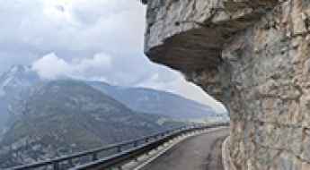
What are the most spectacular roads in Italy?
Located in the southern part of Europe, Italy is a dream for drivers as it hosts the mountain passes (the Alps), coastal drives (Adriatic, Ionian, Tyrrhenian, and Ligurian), and some of the most famous scenic routes in the world.
Choosing only a few roads to drive in the country is nearly impossible, as there are about 600 spectacular routes. Stelvio Pass is Europe's most famous road. At an elevation of 2,757m (9,045ft) above sea level, the pass is located in the northern part of the country. It's one of the highest roads in Europe. Featuring 48 hairpin turns, the road through the summit is a marvel of engineering.
If you prefer coastal drives, you must experience the breathtaking Amalfi Coast Road. The road follows the shoreline from Sorrento south to Salerno. The road has been featured in films since cameras started rolling at 24 frames per second. If you want to feel like James Bond, don’t skip Strada della Forra. A small car with a functioning horn is recommended. For skilled drivers only. The drive is known by motorcyclists from all over Europe, as it is impressive and not without danger in a few narrow and steep spots. If you prefer roads with a story, don’t miss the Strada delle 52 Gallerie, a WWI military mule road. Built on the massif of Pasubio, it was constructed in this position to stay away from Austro-Hungarian artillery fire.
Capanna Tondi Refuge
Rifugio Capanna Tondi is a high mountain refuge at an elevation of 2.347m (7,700ft) above the sea level, located in the Veneto region of Northern Italy.
The unpaved road to Rifugio Sebastiani at Colletto di Pezza
Colletto di Pezza is a high mountain peak at an elevation of 2,102m (6,896ft) above sea level, located in the province of L'Aquila, Italy.
Alpe Soglia
Alpe Soglia is a high mountain peak at an elevation of 1.841m (6,040ft) above the sea level, located in Piedmont in northern Italy.
Col Toront
Col Toront is a high mountain peak at an elevation of 1.615m (5,298ft) above the sea level, located in the Veneto region of northern Italy. The elevation gain is 1.321 meters. The average gradient is 7.33%, with sections up to 16%.
Colle della Lace
Colle della Lace is a high mountain peak at an elevation of 2.047m (6,715ft) above the sea level, located on the border of Aosta and Piedmont regions, in northern Italy.
Travel guide to Kuhleitenhütte
Kuhleitenhütte is a mountain cabin at an elevation of 2.360m (7,742ft) above the sea level, located in Italy’s South Tyrol region.
San Colombano Pass
Passo di San Colombano is a high mountain pass at an elevation of 2.247m (7,460ft) above the sea level, located in the Province of Sondrio, Lombardy region in northern Italy.
Driving the scenic Strada del Lumiei, the Italian road of the tunnels
Strada del Lumiei is the name of a very challenging road with stunning views located in the Province of Udine in the Italian region Friuli-Venezia Giulia.
Monte Cuzzo
Monte Cuzzo is a high mountain peak at an elevation of 2.503m (8,211ft) above the sea level, located in South Tyrol in northern Italy.
Driving the road to Punta Bianca is not a piece of cake
Punta Bianca is a secluded white beach located on Sicily's southwest shore, in Italy, with a horrible road where you can easily damage your car.
Sella Brunech
Sella Brunech is a high mountain peak at an elevation of 2.443m (8,015ft) above the sea level, located in Trentino in the northern Italian region Trentino-Alto Adige/Südtirol.
Malga Campobon is well worth the time
Malga Campobon is a high mountain pass at an elevation of 2.035m (6,676ft) above the sea level, located in the Province of Belluno in the Italian region of Veneto, near the Austrian border.
Lavarella Refuge
Rifugio Lavarella-Berghütte Lavarella is a high mountain refuge at an elevation of 2.045m (6,709ft) above the sea level, located in South Tyrol in northern Italy.
Porta Vescovo
Porta Vescovo is a high mountain peak at an elevation of 2.518m (8,261ft) above the sea level, located on the border of Trentino South Tyrol and Veneto, in northern Italy.
Paion Refuge
Rifugio Paion is high mountain refuge at an elevation of 2.223m (7,293ft) above the sea level, located in Trentino in the northern Italian region Trentino-Alto Adige/Südtirol, located in the Val di Fiemme.
Malga Tasula
Malga Tasula is a high mountain pass at an elevation of 2.094m (6,870ft) above the sea level, located in Trentino in the northern Italian region Trentino-Alto Adige/Südtirol.
Alpe di Tires
Alpe di Tires (Tierser-Alpl) is a high mountain peak at an elevation of 2.456m (8,057ft) above the sea level, located in the Dolomites mountain range, in the South Tyrol province of north Italy.
Colle della Portula
Colle della Portula is a high mountain peak at an elevation of 2.449m (8,034ft) above the sea level, located in the Aosta Valley region of north-west Italy.
Colverde Refuge
Rifugio Colverde is a high mountain hut at an elevation of 1.970m (6,463ft) above the sea level, located in the Trentino province, northern Italy. The average gradient is brutal: 23.33%.
A road with countless tunnels on Ponti di Vara to transport marble to the quarry
Originally built as a railway tunnel, the historic Vara Bridge was constructed in 1876 for marble transportation to the quarries of Carrara, Italy. Today, the bridge is used by trucks and vehicles. It’s one of the most spectacular bridges in the world.
Cima Uomo
Cima Uomo is a high mountain peak at an elevation of 2.480m (8,136ft) above the sea level, located in Trentino in the northern Italian region Trentino-Alto Adige/Südtirol.
Driving the unpaved road to Passo dei Campelli in the Italian Alps
Passo dei Campelli is a high mountain pass at an elevation of 1.896m (6,220ft) above the sea level, located in the Province of Bergamo in the Italian region of Lombardy.
Passo del Muratone
Col de Muraton/ Passo del Muratone is an international mountain pass at an elevation of 1.163m (3,815ft) above the sea level, located on the border of France and Italy.
Colle del Pis
Colle del Pis is a high mountain peak at an elevation of 2.524m (8,280ft) above the sea level, located in the Metropolitan City of Turin, in Italy.
Scoiattoli Refuge
Rifugio Scoiattoli is a high mountain hut at an elevation of 2.257m (7,404ft) above the sea level, located in Veneto, a region in Northern Italy.
Pointe Leysser
Pointe Leysser is a high mountain peak at an elevation of 2.429m (7,969ft) above the sea level, located in the Valle d’Aosta region, in northwestern Italy.
Parafulmine Refuge
Rifugio Parafulmine is a high mountain hut at an elevation of 1.543m (5,062ft) above the sea level, located in the Province of Bergamo in the Italian region of Lombardy.
Road SP269c
Strada provinciale 269c is a very exciting mountain road located in the Campania region, in southwestern Italy. The road offers stunning views of the Tyrrhenian Sea.
Lago di Mucrone
Lago di Mucrone is a high mountain lake at an elevation of 1.901m (6236ft) above the sea level, located in the northern Italian region of Piedmont.
Col de Valvacin
Col de Valvacin is a high mountain peak at an elevation of 2.360m (7,742ft) above the sea level, located in Trentino in the northern Italian region Trentino-Alto Adige/Südtirol.
Capanna 2000 Refuge
Rifugio Capanna 2000 is a high mountain hut at an elevation of 1.972m (6,469ft) above the sea level, located in the Province of Bergamo in the Italian region of Lombardy. The road is very steep, with some parts up to 12%.
Lago Gabiet
Lago Gabiet is a high mountain lake at an elevation of 2.384m (7,821ft) above the sea level, located in the province of Aosta Valley, Northern Italy.
The inhumane climb to Monte Tavolino
Monte Tavolino (Sefiarspitze) is a high mountain peak at an elevation of 2.505m (8,218ft) above the sea level, located in South Tyrol, northern Italy,
Laghi di Champlong
Laghi di Champlong is a high mountain lake at an elevation of 2.353m (7,719ft) above the sea level, located in the Aosta Valley region of north-west Italy.
Colle Plane
Colle Plane is a high mountain pass at an elevation of 2.222m (7,290ft) above the sea level, located on the border of Italy and France.
Driving the SP18 to Ranzo, the road carved into the rock
Located in the Autonomous Province of Trento, in Italy, Strada Provinciale 18 is a road dug into the rock and, at times, overhanging.
