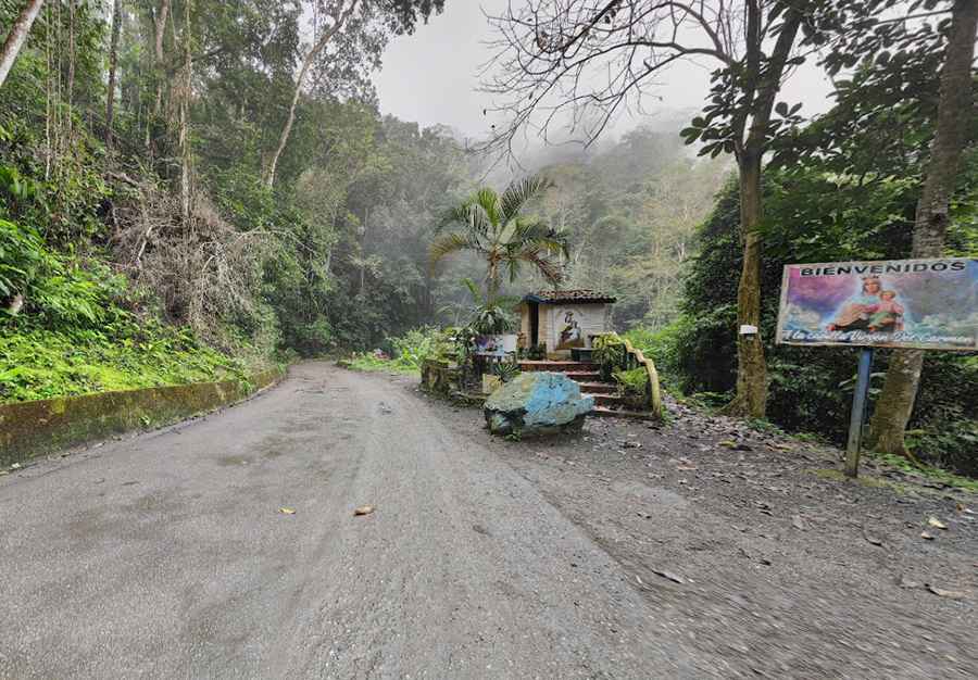
Driving the Maracay-Ocumare de la Costa Road: A Scenic Route to Venezuela's Caribbean Coast
The Maracay-Ocumare de la Costa road (also known as local highway 7) spans 51.6 km (32 miles) and is the only land route connecting Maracay to the Ocumare de la Costa de Oro municipality. This road links Venezuela's central region with Henri Pittier National Park and the Caribbean Sea. Characterized by numerous sharp curves, it travels through the tropical jungle of Henri Pittier National Park, running from Maracay, the capital city of Aragua state, to the small coastal town of Ocumare de la Costa.

Where Does the Maracay-Ocumare de la Costa Road Begin?
The Maracay-Ocumare de la Costa Road starts in Aragua state, at a checkpoint on the northern edge of El Limón near the Rancho Grande Biological Station museum. Here, it continues from Universidad Avenue. Since Henri Pittier National Park was established, special-use zones have been designated along the road from the El Limón checkpoint to the village of La Trilla, including the Cansamacho Bridge. The road then passes through park wetlands before reaching the coast.
What is the El Limón Checkpoint on the Maracay-Ocumare de la Costa Road?
At the metropolitan entry to Maracay through El Limón, a military checkpoint serves the Maracay-Ocumare de la Costa Road. Initially established as a post for Company No. 1 of Detachment 21 under the Venezuelan Armed Forces, the area also hosts the Vegetation Fire Fighting and Extinction Operations Center and facilities for flora and fauna protection, as well as reforestation services (CONARE).
How Did the Maracay-Ocumare de la Costa Road Develop?
The road’s development dates back to Venezuela’s colonial era when military engineer Agustín Codazzi mapped routes, including one connecting Ocumare's port with Maracay. In 1910, Venezuelan President Juan Vicente Gómez decreed the construction of the road, which was initially built by prisoners. The project was first overseen by engineers Alí Gómez Bello and E. González Lozada; later, in 1914, Luis Vélez led the work, which officially opened in May 1916. The road underwent significant upgrades over the years, including in 1917 with funding from international companies. By 1927, it was fully mapped and maintained at a cost of 61,000 bolivars.
How Was the Maracay-Ocumare de la Costa Road Used During the Independence Era?
During Venezuela’s War of Independence, patriot forces frequently used the Maracay-Ocumare de la Costa Road as a supply route between Ocumare and the Aragua Valleys. The road, which was mainly flat but rocky, connected Ocumare and its cacao estates to the northern slopes of Henri Pittier. Both sides of the road were lined with large cacao plantations and some residential houses, creating a vital path for the transport of goods and movement of troops.
What is the Terrain Like on the Maracay-Ocumare de la Costa Road?
The Maracay-Ocumare de la Costa Road begins at kilometer 0, at a checkpoint north of El Limón, at an altitude of 440 meters (1,443.6 feet) above sea level. From there, it ascends along the national park’s southern slopes with gradients generally under 5%. After approximately 23 kilometers within the park, the road reaches the Henri Pittier summit at 1,120 meters (3,674.5 feet), near the Rancho Grande Biological Station. The descent follows the northwest slope, with more flat sections to avoid large rock cuts, and eventually levels out close to sea level in the Aponte sector, crossing the Ocumare River on three bridges before reaching Ocumare de la Costa.
Is the Maracay-Ocumare de la Costa Road Paved?
Yes, the Maracay-Ocumare de la Costa Road is fully paved with asphalt concrete and cement. However, the road often shows wear, especially in areas with sharp curves, many of which feature compensatory banking. Due to constant use and climate conditions, the road is prone to cracks, potholes, and unmarked obstacles, especially during the rainy season. The road serves cars, buses on the Maracay-Ocumare route, and motorcycles.
What Challenges Does the Maracay-Ocumare de la Costa Road Face?
Frequent flooding and landslides pose significant challenges along the Maracay-Ocumare de la Costa Road, especially between kilometers 7 and 11 during the rainy season. The road’s location within Henri Pittier National Park’s wetlands makes it particularly vulnerable to seasonal hazards that can cut off access to the coast.
What Happened During the Tragedia del Limón on the Maracay-Ocumare de la Costa Road?
In 1987, the Maracay-Ocumare de la Costa Road was affected by a catastrophic landslide known as the Tragedia del Limón, triggered by heavy rain from the hills of Henri Pittier National Park. The landslide caused extensive damage and significant loss of life, with estimated fatalities ranging from 100 to 300 people, and hundreds more missing or injured. Thousands of residents and visitors were impacted, while vacationers on the coast were stranded as part of the road collapsed. The tragedy remains a stark reminder of the region’s susceptibility to natural disasters and the need for preventive measures.
Road suggested by: jorge manuel gómez sánchez
Pic: JAKY 47