How to get by car to High Rock Bay in Michigan's Keweenaw Peninsula?
High Rock Bay is a very scenic spot located in northeastern Keweenaw County in the U.S. state of Michigan. A variety of vehicles try to make it out to the end, but most will turn around. The road can be rough if there has been rain and it hasn't been graded.
Where is High Rock Bay?
The bay is located in the northeastern part of Michigan and offers stunning views of the blue waters of Lake Superior.
How long is the road to High Rock Bay?
The road to the bay is entirely unpaved and comprises Mandan Road and High Rock Bay Road. This drive starts after exiting Copper Harbor (47°27'52.3"N 87°50'26.6"W), also known as the beginning of US Highway 41. The drive is around 12km (7.7 miles) long. The unpaved road is prone to turning swampy, making this a popular destination for overlanders.
How’s the drive on Mandan Road?
The first 7km (4.8 miles) of the road are called Mandan Road. It’s a well-used ATV trail.
How’s the drive on High Rock Bay Road?
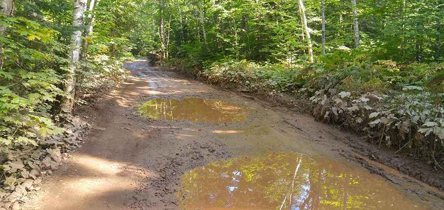
The last part of the drive is called High Rock Bay Road. It’s 4.66km (2.9 miles) long. It's a pretty rough ride, with a lot of potholes, ruts, and bouncing around. Be careful: the road has giant potholes that are often filled with muddy water. It is not suggested to try to find it in a little car. You need to pay attention to turns. You definitely need a 4x4 to get through there on stormy days especially.
Is High Rock Bay worth it?
At the end, the road splits to go to the Keweenaw Rocket Range and High Rock Bay. The views of the lake and of Manitou Island are beautiful. The journey offers superb views. Travelers will be rewarded with a panoramic view of Lake Superior and Manitou Island, as well as the historical landmark of the rocket range. Great camping as well.
Road suggested by: Andrew B