Conquer the Ultimate Road Trip: Driving Alaska's Remote and Treacherous Dalton Highway
Alaska has some of the coldest roads on the planet, but there’s one more extreme than the rest: the Dalton Highway is one of the most isolated roads in the world. If you can drive this road, you can pretty much drive anything; it's a trip to America’s last remaining wilderness. It’s said to be the loneliest road on the planet.
When was the Dalton Highway built?
The road, usually referred to as the Dalton Highway (and signed as Alaska Route 11), was initially built in 1974 as a supply route for the Trans-Alaska Pipeline System and is named after James Dalton, the Alaska-born engineer who directed and supervised its construction. The highway runs parallel to the Trans-Alaska Pipeline System, and despite its bleak, isolated, and remote setting, Linking Fairbanks and oil fields to the north, huge trucks are its main traffic. Giving them the right of way is one of the road rules; the other is taking survival supplies and knowing how to use them.
How long is the Dalton Highway?
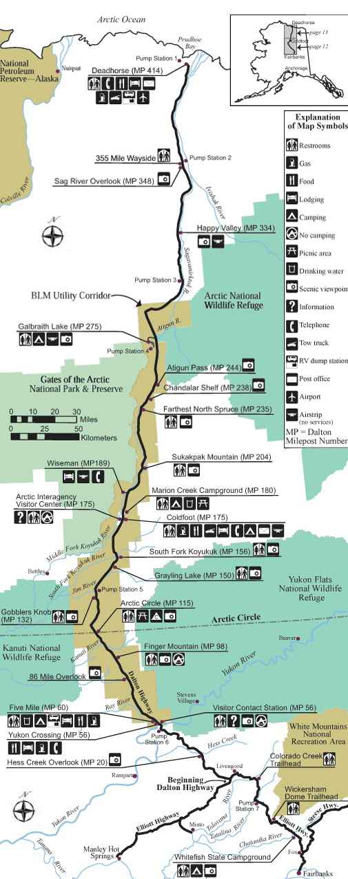
It’s one of the world's northernmost roads. Many who have driven the Dalton Highway have called it "the ultimate road trip." Proper preparation is essential to having a safe, enjoyable visit. Due to the remoteness of the Dalton Highway, take special care to ensure that your vehicle is ready for the trip. The James W. Dalton Highway is a two-lane gravel road that stretches for 414 miles (666 km), a similar distance to that from Washington DC to Boston. It runs between the Elliot Highway just north of the city of Fairbanks and Deadhorse near the Prudhoe Bay oil fields and the Arctic Ocean. One hundred nine miles (175 km) of the highway are sealed. The road itself is very primitive in places, and small vehicle and motorcycle traffic is highly discouraged.
Where does the Dalton Highway start and end?
Anyone embarking on a journey on the Dalton is encouraged to bring survival gear, and the trip is unnavigable for anyone other than pros in modified trucks with plenty of supplies. The Dalton Highway remains the main supply road for the Prudhoe Bay oilfields, and it is constantly navigated by large tractor-trailers and articulated lorries. These monstrous vehicles often throw up large rocks from the gravel road surface, which could easily destroy the bodywork and any glass in a common vehicle. This amazing adventure carves a path through the forest and tundra, crosses the Yukon River, traverses the towering Brooks Range, and passes over the North Slope to end at the Arctic Ocean. The road begins at Milepost F 73.1 on the Elliott Highway, 84 miles from Fairbanks, and ends—for the general public—at Deadhorse/Prudhoe Bay, a few miles short of the Arctic Ocean.
Is the Dalton Highway challenging?
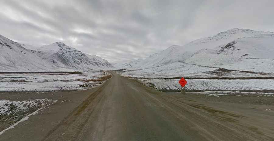
Fuel is only available at three places over the entire course of the route; headlights must be switched on at all times, and there are a number of steep gradients over its course. The road reaches its highest altitude as it crosses the Brooks Range at Atigun Pass, at an elevation of 4,739 feet (1,444 m) above sea level. All vehicles must take extreme precautions when driving on the road and drive with headlights on at all times. There are quite a few steep grades (up to 16%) along the route as well. As the main supply route for the Prudhoe Bay oilfields, this road is extremely treacherous. It is heavily used by large tractor-trailers that kick up thick clouds of dust, mud, and gravel, which significantly reduces visibility.
8 rules for Dalton Highway
According to the U.S. Department of the Interior, Bureau of Land Management, there are eight rules on this road: Big trucks have the right of way, always drive with your headlights on so others can see you, keep your headlights and taillights clean so they are visible, stay on the right side of the road, don't stop on bridges or hills, check your rear-view mirror regularly, if you spot wildlife, pull over to a safe spot before stopping, slow down when passing other vehicles (especially bicyclists and motorcyclists) to lessen the chances of hitting them with mud or flying rocks from your tires.
Why is the Dalton Highway so dangerous?
Portions of the Dalton Highway may be temporarily closed due to road work or inclement weather. Traveling this farthest-north road involves real risks and challenges, and it can be dangerous because the highway is essentially just a gravel road, reduced to zero visibility, enormous potholes, and extreme Arctic weather. Services are available at only a few places along the Dalton Highway, so proper planning is essential. There are no public services at the Department of Transportation maintenance stations or Alyeska Pipeline Service pump stations. This isolated highway was built as a supply road to support oil exploration in Alaska. There are just three towns on the way, with a total population of 60 people. The giant trucks that ply the route kick up huge clouds of dust, reducing visibility to zero; drivers need to be aware of mammoth potholes. There is also freezing Arctic weather to contend with. If you are driving your personal vehicle, it is important to remember that the purpose of this highway is for trucks, and the road is designed for them rather than for personal vehicles. The road is known for being particularly deadly. With crosses littered throughout in memory of those that have lost their lives, it's no surprise. The road has bad conditions, poor visibility, and sudden 2-4 lane changes, all contributing to the many fatalities. Traffic police officers are accustomed to accidents along the route, and they conduct regular helicopter patrols for accidents and truck breakdowns. The highway does not have exits, making it very hard for drivers to access emergency services in case of an accident.
Is the Dalton Highway remote?
Known as the loneliest road on earth, you’ll face great distances without seeing another soul, so remote isn’t even the word. The trip on the road is really an ultimate trip. The speed limit is 50 mph. The road is locally called the Haul Road, and June to mid-July is the ideal time for driving this route. Motor vehicle travel should be done by pickup, SUV, or AWD, high-clearance car only. Small cars and motorcycles are highly discouraged. The road is extremely primitive in places, and small car and motorcycle wrecks are extremely common. Most motorcycle wrecks result in injuries, and the nearest EMS and medical services are in Coldfoot and Deadhorse. There is no cell phone coverage on the road, and some satellite phones do not work within the Brooks range. It's the longest stretch of serviceless road in North America with no gas stations, restaurants, hotels, or any other basic services. Motorcycles are extremely discouraged from making the journey. Few roads in the world offer the degree of isolation as the James W. Dalton Highway. Make sure you pack plenty of supplies because there are only three villages along this 666km road through the wilderness. The highway is one of the most isolated roads in the United States. There are only three towns along the route: Coldfoot, at Mile 175, Wiseman at Mile 188, and Deadhorse, at the end of the highway at Mile 414.
Can I drive the Dalton Highway?
An interesting fact about Alaska is the state where the lowest temperatures in the US were recorded. and the highway winds through steep melted passes. Check weather forecasts before leaving home, and remember that it becomes cooler and often more prone to storms at higher elevations. The climate of the regions this highway traverses ranges from subarctic to polar. During the summer months (Jun-Aug), the average maximum temperatures range from 70°F (21°C) to 50°F (10°C), with average minimum temperatures ranging from 50°F (10°C) to 35°F (2°C). Travel on the highway during the months of May and September is a bit colder, although travel along the highway is not considerably more dangerous during these months. Along the way, we’re probably seeing anywhere from 30 to 50 trucks a day delivering supplies, including food and fuel. When the highway is closed, there is an estimated 1 million dollars a day in economic loss. The Dalton Highway is open year-round.
When can I drive the Dalton Highway?
The road is mostly built on top of the icy permafrost. Sudden changes in the weather can make driving even more dangerous. High risk of avalanches. Feel like getting away from civilization? Then this is the highway for you. The scenery is gorgeous, but you may be too busy dodging potholes the size of moon craters, battling strong winds flinging small rocks at your car, or trying not to freeze in -80°F, all of which could leave you stranded in the middle of nowhere. Expect a lethal road with oversize trucks in the middle of an area prone to avalanches and high winds. The ice road is pretty narrow in some sections, with sharp turns and really steep grades up to 16%. Low visibility due to the snow and fog is also an issue. Several features of the road have their own names, including: The Taps, The Shelf, The Bluffs, Oil Spill hill, Beaver Slide, Avalanche Alley, Gobblers Knob, Two and a Half Mile, Oh Shit Corner, and the Roller Coaster. It is very important to check the road conditions and weather warnings and forecasts before leaving, especially outside of July and August. Dalton’s climate can make driving conditions challenging, and avalanches are a common winter hazard.