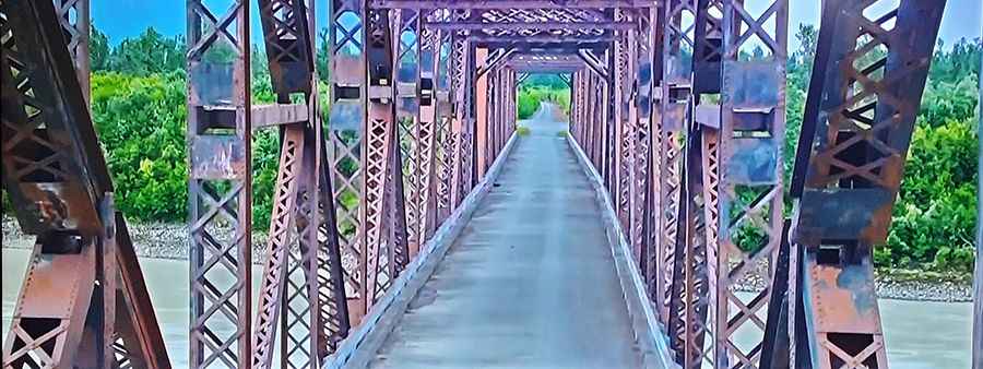
Miles Glacier Bridge is the bridge to nowhere in Alaska
The Miles Glacier Bridge, completed in the early 1900s, spans the Copper River in Alaska and is notable for its multiple-span Pennsylvania truss design. Built to facilitate a 196-mile railroad line for the Copper River and Northwestern Railway, the bridge was essential for transporting copper from the mining town of Kennicott to the port of Cordova. It is considered one of the most spectacular bridges in the world.

Why is Miles Glacier Bridge nicknamed as the Million Dollar Bridge?
The bridge earned its nickname due to its construction cost of $1.4 million, which was offset by approximately $200 million worth of copper shipped as a result.
How Can You Access the Bridge?
Access to the bridge is now limited to jet boat travel up the Copper River or downstream boat travel from Chitina, as erosion along the Copper River Highway has restricted road access. Despite its historical significance, repairs have been hindered by funding issues, although it remains a tourist attraction.
When Was the Bridge Built?
Constructed between 1906 and 1911, the bridge was the most significant of the associated structures built by Michael James Heney. Its use as a railroad bridge ended in 1938 when the railway shut down. The bridge was converted for highway use in 1958, during which a plaque commemorating its history was installed.
How Did the Bridge Survive the Earthquake?
The bridge survived the 1964 Alaska earthquake with only minor damage, though one span slipped from its foundation. It was listed on the National Register of Historic Places in 2000. The bridge was re-opened to highway traffic in 2005. However, the Copper River Highway is currently closed beyond mile 36, where there is a failed bridge.
What Are the Bridge’s Key Features?
Designed to withstand the powerful currents and ice conditions of the Copper River, the bridge features four spans, with lengths of 400 feet, 300 feet, 450 feet, and 400 feet. Following severe flooding in 1995, repairs were initiated in 2004, and the completed structure was dedicated in 2005 at a cost of $19 million. However, in 2016, a large iceberg struck an icebreaker protecting one of the bridge's piers, leading to concerns about the bridge’s structural integrity.
What Happened to Other Bridges Along the Copper River?
While the Miles Glacier Bridge remains intact, Bridge 339, a major crossing over one of the Copper River channels, washed out in 2011, and there is little chance of its replacement. Notably, the two bridges spanning the eastern channels of the Copper River, along with the Flag Point Channel Bridge, were poorly planned, reflecting a lack of understanding of the river's dynamics. The Copper River originates from numerous glaciers across the Chugach, St. Elias, Wrangell, and Alaska Ranges, carrying vast amounts of sediment downstream and creating braided river systems.
The river can switch its main flow between the Flag Point Channel and the East Channel roughly every 30-35 years. After the Flag Point Channel filled with sediment in the early 2000s, the river’s main flow diverted to the East Channel, impacting bridges not designed for such high flows. Efforts to remediate the situation were ultimately unsuccessful, resulting in the loss of Bridge 339. Meanwhile, the Flag Point Channel Bridge stands high over a nearly dry channel, built to withstand the raging river but now stranded. While the river channels will continue to shift, the future of the bridges over the East Channel remains uncertain, including whether engineers will endeavor to restore access to the recreational and historical sites upstream, including the Miles Glacier Bridge.
Road suggested by: Jack Dalton