Caminito del Rey Is a Thrilling Journey Through Malaga’s Most Dangerous and Stunning Gorge
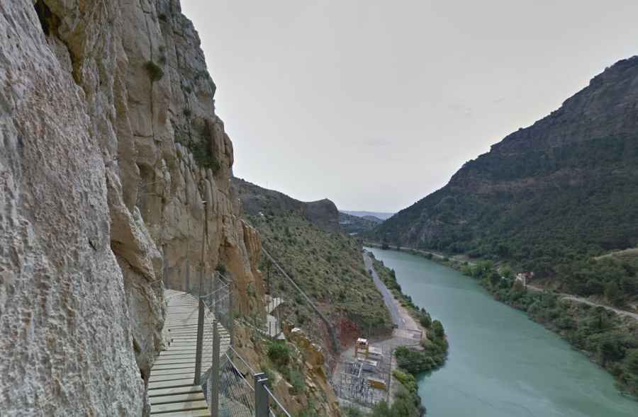
Caminito del Rey is a pedestrian walkway constructed along the cliffs of the Gaitanes Gorge, located between the municipalities of Ardales, Álora, and Antequera in the Malaga province, Andalusia, Spain. The path stretches over three kilometers with an additional 4.8 kilometers of access routes. It is attached to the rock walls within the gorge, with sections that are only one meter wide, hanging up to 105 meters (344 feet) above the river, on steep cliff faces.
Why was Caminito del Rey originally built?
The walkway was originally constructed by the Sociedad Hidroeléctrica del Chorro between 1901 and 1905. It was designed to provide access for maintenance workers, material transport, and surveillance at the Gaitanejo and El Chorro hydroelectric plants. The walkway started near the train tracks and ran through the Gaitanes Gorge. During the construction of the Guadalhorce-Guadalteba reservoirs between 1914 and 1921, the area attracted many visitors, including family and friends of the chief engineer, Rafael Benjumea, and other interested engineers. The natural beauty of the route led Benjumea to improve it and even reform the bridge connecting the two sides of the gorge. The walkway was inaugurated in 1921 by King Alfonso XIII, who is said to have either crossed it or visited the path during the opening of the reservoirs. Since then, the path has been known as Caminito del Rey (The King’s Little Path).
How dangerous was Caminito del Rey before its restoration?
The lack of maintenance over time caused significant deterioration to the Caminito del Rey, especially in the 1990s, when the path was in a dangerous state, with no railings, collapsed sections, and precarious remaining beams. This made the trail highly dangerous and led to several fatalities, contributing to its notorious reputation. Many hikers ventured to El Chorro to walk the trail, and its popularity among climbers, one of the most significant climbing areas in Europe, resulted in frequent accidents, some of which were fatal.
How was Caminito del Rey restored?
In 2006, the Málaga Provincial Government, in collaboration with the Junta de Andalucía, included a restoration project in their budget. In 2009, the plans for the restoration were put out for bid, with a budget of 5 million euros. Work on the path began in 2014 and lasted approximately one year. The newly restored path was opened to the public on March 28, 2015, and received attention from various media outlets, including being named one of the best places to visit in 2015 by Lonely Planet.
In May 2017, the entire stretch of the trail was equipped with 4G coverage, and a visitor center was under construction near the north access (Ardales). This center will include information points, souvenirs, a café, restrooms, and parking for up to 200 cars and 17 buses. The center was completed in January 2018 but was still closed to the public at the time.
How long is Caminito del Rey?
The Caminito del Rey is approximately 7.7 kilometers long, with 4.8 kilometers being access roads and 2.9 kilometers consisting of the walkway itself. The walkway section is divided into 1.5 kilometers of wooden walkways and 1.4 kilometers of forest trail. The path winds through dramatic landscapes within the Gaitanes Gorge, where the Guadalhorce River flows through steep limestone cliffs. In some parts, the gorge is less than 10 meters wide, and the cliffs can rise up to 300 meters (984 feet).
How dangerous is Caminito del Rey today?
Although Caminito del Rey has been restored and made much safer, it still offers an exhilarating experience. The new wooden walkways are secured with railings for added safety. However, the path is still narrow in parts, and it is important to be cautious when walking along the precipitous cliffs. While the trail is much safer, it’s not without risks, and visitors are still encouraged to follow all safety guidelines. Between 2001 and 2018, at least six people died on the trail, emphasizing the potential dangers, especially for those with vertigo.
Is Caminito del Rey open to vehicles?
The Caminito del Rey is closed to vehicles and is only accessible on foot. For visitors, there is a shuttle bus service between the north access (Ardales) and the south access (El Chorro), at a nominal fee, to help people return to their starting point.
How can I visit Caminito del Rey?
To visit the Caminito del Rey, you must purchase tickets in advance through the official website. Visitors can take the shuttle bus to reach the north or south access points. The trail is now open to the public year-round, but reservations are required to manage the number of visitors.
What makes Caminito del Rey a popular attraction?
Caminito del Rey has become one of the most popular hiking destinations in Andalusia due to its spectacular views and challenging terrain. Walking through the Gaitanes Gorge offers stunning views of limestone cliffs, and visitors may even spot wildlife, including mountain birds like griffon vultures and golden eagles, or wild boar and mountain goats. The path provides unforgettable panoramic views, making it a must-visit for adventure enthusiasts and nature lovers.
Has Caminito del Rey been featured in films?
Yes, Caminito del Rey has appeared in several films, including:
- Von Ryan's Express (1965) – starring Frank Sinatra and Raffaella Carrà. Some scenes were filmed along the train tracks near the gorge.
- The Bridge of San Luis Rey (2004) – features the path as one of the locations.
How long does it take to walk Caminito del Rey?
The entire route of Caminito del Rey typically takes 4 to 5 hours to complete, depending on your starting point. Visitors are advised to wear comfortable clothing and sturdy shoes suitable for walking along the narrow and high walkways.
What should I know before visiting Caminito del Rey?
Before visiting, ensure that you are physically fit and comfortable with heights, as the trail has some narrow sections with steep drops. Make sure to book your tickets in advance and check the weather forecast, as the trail can be closed in extreme weather conditions.