The military road to Fort de la Redoute in Savoie
Fort de la Redoute is a high mountain fort at an elevation of 2,346 m (7,696 ft) above sea level, located in the Savoie department of France.
Where is Fort de la Redoute?
The fort, also known as Fort de la Traversette, is located at the Col de la Traversette, in the Auvergne-Rhône-Alpes region in the south-eastern part of France, near the Italian border.
When was Fort de la Redoute built?
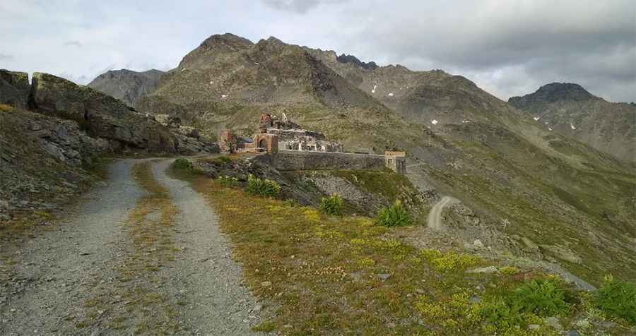
A redoubt was first built on the Col de la Traversette in 1630 by the House of Savoy. After Savoy was annexed by France in 1792, the French took over the structure in 1794 and renamed it Fort-Libre. When Savoy became French again in 1860, a new advanced post was built near the col from 1891, later expanded and named Redoute-Ruinée after the old ruined fort. It was occupied by Chasseurs Alpins units and even visited by President Félix Faure in 1897.
The fort was strengthened between the late 19th and early 20th centuries, receiving walls, an observatory, a drawbridge, and later bombproof shelters and a casemate. In World War II, it served as an Alpine outpost of the Maginot Line. During the Battle of the Alps in 1940, around 70 French soldiers held out against Italian assaults until surrendering on 3 July 1940, after the armistice. German troops later occupied it, surrendering in April 1945. Access to the fort is actually prohibited because of the danger of collapse. After the war, the site became part of the La Rosière ski area and is now a stop on hiking and trail routes.
Is the road to Fort de la Redoute unpaved?
Set high in the Cottian Alps, a mountain range in the southwestern part of the Alps, the road to the summit is an old military track. It’s totally unpaved and impassable in winter due to the snow. It’s a trail only for 4x4 or enduro. After rain, it’s impassable.
How long is the road to Fort de la Redoute?
Starting and ending at the paved D1090 Road, the road to the fort is 8.9 km (5.53 miles) long. The unpaved climb is very rideable, with stunning views and some history at the summit.
Pic: Radovan Podmanický