Norikura Skyline Road is the highest public road in Japan
Located in Nagano Prefecture, in the central Chūbu region of Japan, the paved Norikura Skyline is a great road with stunning views.
What is the highest paved road in Japan?
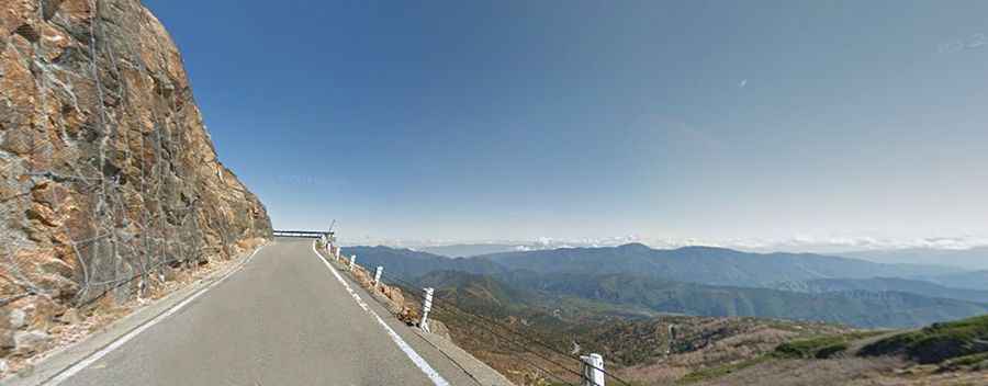
Set high on the southern edge of the Northern Japan Alps, the Norikura Skyline Road climbs up to Mount Norikura, a massive stratovolcano at 2,700m (8,858ft) above sea level. At this elevation, it’s the highest public road in Japan. The high point of the road is not actually Mount Norikura’s summit. This can be reached only by foot.
Is the Norikura Skyline Road open?
This toll road is usually closed for more than half the year due to extremely heavy snowfalls in the higher parts of the mountains. There are walls of snow over 10 meters high on the road. Even in the summer, some snow remains on the northeastern face of the mountain. The road is open from May 15th to October 31st and available from 7:00 AM to 6:00 PM during May, June, October, and from 3:30 AM to 6:00 PM during July, August, and September. It is closed to private cars at 1,800m above sea level: only buses, taxis, and bicycles are allowed.
Is the Norikura Skyline Road worth it?
The experience of using this road, opened to traffic in 1973, is very impressive. The drive is definitely worth it and the views of the Yarigatake and Hodaka Mountain Range are marvelous. Along the way, drivers can enjoy a great panoramic view of the Northern Alps Mountain Range. When travelers arrive at the last stop of Tatamihira, they should take a walk around. They can enjoy the scenery of alpine plants and Pinus pumila trees and can also see groups of birds.
How long is the Norikura Skyline Road?
The road is totally paved. It is a toll road that was built at the highest point above sea level in Japan and runs from Hirayutouge to Norikuradake Tatamihira. The road is 6.5 m in width and covers a total distance of 14.4 km (8.94 miles).
Is the Norikura Skyline Road in Japan hard?
It’s a pretty steep drive, hitting a 12% maximum gradient through some of the ramps. This route has 10 tunnels on roads with no shoulders.