How to get by car to Kondaveedu Fort in Andhra Pradesh?
Kondaveedu Fort is an ancient hill fortress at an elevation of 292m (958ft) above sea level, located in Guntur district, in the Coastal Andhra region of the Indian state of Andhra Pradesh.
Why is Kondaveedu Fort important?
The fort is located atop a forested hill, offering panoramic views. It was built by Anapotha Reddy, a ruler of the Reddy Dynasty in the 13th century AD. Today, the massive fortifications and battlements are in ruins. In addition to the main fort, there are two other forts nearby.
Is the road to Kondaveedu Fort paved?
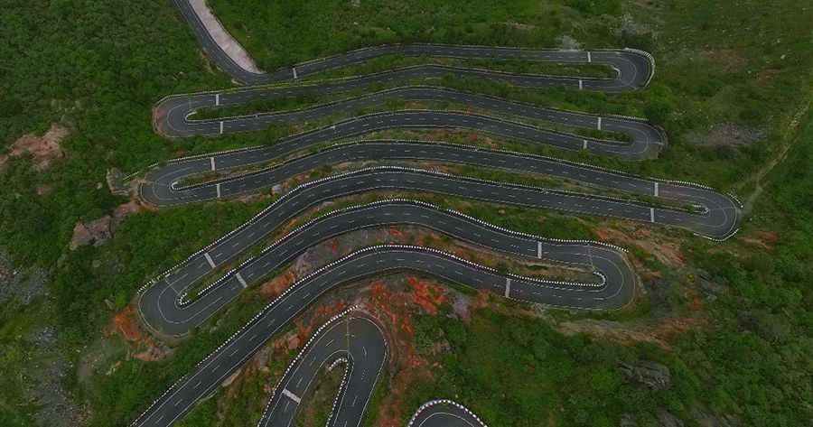
Tucked away in the Eastern Ghats, the road to the fort was recently built and is fully paved. It’s called Kondaveedu Ghat Road. The road is not easy, as it includes 17 hairpin turns. The best time to visit is from November to March.
How long is the road to Kondaveedu Fort?
The road is 8.1km (5.03 miles) long, starting at Ghaneshwarapadu. The drive is very scenic, passing through an oval hill in the middle of a reserve forest, with panoramic viewpoints along the way.
How steep is the road to Kondaveedu Fort?
The most challenging part of the road is a 3.4km long section near its end, with a series of 14 hairpin turns. Over this distance, the road is very steep, reaching a 12% maximum gradient on some ramps. The elevation gain is 152 meters, and the average gradient is 4.47%.
Road suggested by: jorge manuel gómez sánchez