Driving the 208 Bends of the Panlong Ancient Road
Located in the Kashgar region of the Xinjiang Uygur Autonomous Region in China, the Panlong Ancient Road is not for the faint of heart or anyone prone to motion sickness.
How long is Panlong Ancient Road?
Tucked away in the Pamir Plateau, in the Kunlun Mountains, the winding road to the summit is known as the Pamir Plateau Sky Road, Pamir's Sky Road, and Wacha Road. It’s 36km (22 miles) long and opened in July 2019 to facilitate the passage through the Pamirs for the region's mountain farmers and herdsmen. Foreign tourists need to apply for a border pass to Tashkurgan in Kashgar.
Where does Panlong Ancient Road start and end?
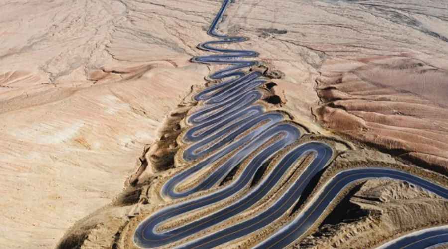
The dangerous road connects the town of Habu Sikalai in Waqia (on the Bandi Dailiya River, X614 county road) to the east with Taxkorghan township to the west (G314 national road, KKH) next to the Tashiku'er River. It has over 208 bends, so be careful when driving, especially when turning, encountering rain or snow, and be cautious of mudslides.
Is Panlong Ancient Road paved?
At its highest point, the road is 4,269m (14,005ft) above sea level, at the summit of Wuguliyate Daban. The climb is steep, hitting an 11.8% maximum gradient through some of the ramps. The road was entirely paved in 2020, a few months after irs construction. It’s a driving enthusiast's dream.
Is Panlong Ancient Road open in winter?
Since 2023, the Panlong Ancient Road has been temporarily closed each year from late October to late March. This seasonal closure aligns it with other popular roads in Xinjiang, such as the Yizhao Highway and Duku Highway.
Road suggested by: jorge manuel gómez sánchez
Pic&more info: https://ninefeetapart.com/blog-1/f/the-dangerous-road-hidden-in-the-pamirs-----panlong-ancient-road