Discover the Thrills of Lysevegen: Norway's Famous Hairpinned Road
Located in the southwestern part of Norway, Lysevegen is a very popular tourist road in the high mountains of Rogaland and Vest Agder. The road features 27 hairpin turns and a curvy narrow tunnel, impassable for 2 cars at the same time. It's not a small road; it's one of the famous hairpinned roads in the world.

Where is the Lysevegen road?
Lysevegen (FV500) is located on the boundary between Agder and Rogaland counties, in the southwestern part of Norway.
When was Lysevegen road built?
The road, heralded as one of the most spectacular roads in the world by dangerousroads.org users, was built as a works road during the construction of the Tjodan hydroelectric power station and was officially opened in 1984. Prior to that, boats were the only regular means of communication with the outside world for people in Lysebotn. The first road was built in 1953-64 inside the mountain, and it was used to dispose of all the removed stone masses during construction.
How long is the Lysevegen road?
The road is entirely paved. Starting at Fv450, the road is 32.6 km (20.25 miles) long. It ends at Lysebotn, a small village at the eastern end of the Lysefjorden in a very isolated valley.
Is the Lysevegen road in Norway dangerous?
The road tops out by Andersvatn lake, at an elevation of 932m (3,057ft) above sea level. The road is dangerous due to its 27 sharp hairpin bends, an average gradient of 9.4%, and twists and turns on a single-track road. Drivers need to be extremely careful. It hits a maximum gradient of 16% through some of the ramps. It is a long road, twisting and turning the whole way down. People must take their time and be exceedingly careful driving this endlessly winding road. Tight corners and reverse camber bends greet you for the 20 miles of this mountainous road, but it’s the last section of the road that will really challenge even the most experienced of drivers. Along with stunning views, it features no fewer than 27 hairpin bends in a row. Two main reasons to travel this road - apart from experiencing the road itself - are the walk to Kjerag and the ferry through Lysefjord, back towards Stavanger. Not content with offering hairpins alone, the road drops nearly 1,000 meters before finishing off with an impressive tunnel that turns 340 degrees before you emerge in the quiet town of Lysebotn. Your head may be in a spin by the end, but this is as good as it gets. It can be very narrow at times, so you often have to stop to let drivers coming from the opposite direction pass.
Is Lysevegen road open?
This narrow road is only open for 5 months of the year. It has the reputation of being very misty. This road is only open in the summer when it is ice-free and safe. It opens in May and closes in October/November (depending on snow conditions). Both dates are selected by the weather, not by people - sometimes it can be quite late in May before the snowplows finish their work, and you can still see snow well into the summer. Even in June, you can experience snow along the road. At the summit, there is a lot of snow in the winter.
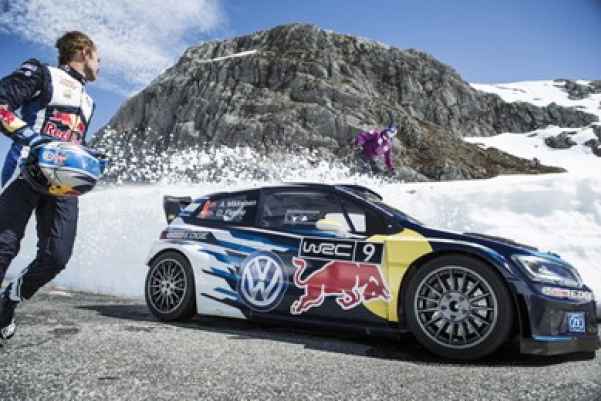
Can a WRC car beat a professional skier down the Lysevegen hairpins?
The technical complexity of the Lysevegen Road is so extreme that it was chosen as the ultimate playground for a high-stakes race between two Norwegian legends: downhill skier Aksel Lund Svindal and WRC star Andreas Mikkelsen. The mission was a race against the clock to catch the last ferry leaving Lysebotn, a task that required pushing a Volkswagen Polo R WRC to its absolute limits on the 27 hairpins of the descent.
Driving this road at competitive speeds is a brutal test of mechanical focus. As seen in the footage, Mikkelsen has to manage the car's weight on a "white corridor" of asphalt flanked by massive snow banks, where a single lock-up would mean a terminal collision with the mountain face. The video showcases the sheer verticality of the route, with Svindal jumping over the road as the rally car drifts through the tight, damp hairpins below. This isn't just a stunt; it is a raw demonstration of how the Lysevegen demands perfect control of traction and braking power under high-altitude pressure. Watch the full descent below to see the 27-turn spiral in action.