What are the most spectacular roads in Iceland?
Located in the northern part of Europe, Iceland is a country that provides an unparalleled road trip experience, with mountain roads and coastal drives, mixed with 4x4 trips. Some of the roads, due its dangerousness are for 4x4 vehicles only. Some others are just for special vehicles, having to cross rivers.
Located in the North Atlantic Ocean, the country covers 103,000 square kilometers. It’s famous for its dramatic landscapes with volcanoes, geysers, hot springs, lava fields, and roads! When travelling to the country, remember to drive the Road 622, a hazardous drive below sea level when the tide is high. It’s one of the most challenging drives on Earth, with the road carved into and under cliffs. If you have a Jeep, 4x4 experience, time, and strong nerves, driving this road is possible.
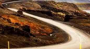
Another must do is driving the Askja Road, one of Earth's most scenic trips. It’s a winding dirt track running towards Askja volcano, a stratovolcano situated in a remote part of the central highlands. The road has some challenging sections with several fords and river crossings. Keep in mind it’s a very dangerous drive. If you prefer paved roads, Diamond Circle is an epic adventure for you. Running through the most incredible spots in the northeastern part of Iceland, it is an epic and unforgettable adventure.
Road 590 (Klofningsvegur)
Road 590 (Klofningsvegur) is a very scenic bumpy route located in the mountainous Klofningsvegur Peninsula, in Western Region, on the western coast of Iceland.
Secrets Of The Ring Road: Iceland’s Epic Road Trip
Ring Road, also known as Route 1, is a national road that runs around Iceland. It is 1,332 Kilometres in length, and connects most of the towns and landmarks together in Iceland. From Reykjavik it goes north to Blönduós and Akureyri, to the eastern city of Egilsstaðir, down to Höfn, and finally follows the south coast back to Selfoss.
Siglufjardarskard Pass requires slow, careful driving
Siglufjardarskard is a mountain pass at an elevation of 701m (2,299ft) above the sea level, located on the border of Northeastern and Northwestern regions, in the north of Iceland. The road is not for those who are afraid of height. The road requires slow, careful driving.
Road F333 (Haukadalsvegur)
F333 (Haukadalsvegur) is a scenic journey located in the Southern Region of Iceland. It's only suitable for 4x4 vehicles with very high ground clearance: along the way there is a small river crossing a few km north of the Haukadalskirkja Church.
Almannaskard Pass
Almannaskard is a mountain pass at an elevation of 162m (531ft) above the sea level, located in the Eastern Region of Iceland.
Driving the Road 643 in Iceland to the end of the world
Road 643 (Strandavegur) is a very remote drive running along the coastline of the Westfjords region of Iceland.
Road F508 (Skorradalsvegur)
Situated in the Western Region of Iceland the F508 (Skorradalsvegur) is a difficult journey with breathtaking landscapes and rugged with rivers. Only for 4x4 vehicles with significant fording capacity. No service or network.
How do you get to Dettifoss waterfall in Iceland?
Located in the Northeastern Region of Iceland, Dettifoss waterfall is said to be the second most powerful waterfall in Europe measured by volume of water.
Road F903 (Hvannalindavegur)
Located in the Eastern Region of Iceland the F903 (Hvannalindavegur) is an exciting journey with breathtaking landscapes following a small river and crossing it twice.
Oddsskardsgong
Oddsskardsgong is a mountain tunnel at an elevation of 631m (2,070ft) above the sea level, located in eastern Iceland.
Road 24 (Ingjaldssandsvegur)
Located on the Westfjords, a large peninsula in northwestern Iceland, Road 24 (Ingjaldssandsvegur) is one of the most remote drives of the country. The road requires slow, careful driving.
Road trip guide: Conquering Steingrimsfjörðurheiði pass
Steingrimsfjörðurheiði pass is a mountain pass at an elevation of 440m (1,443ft) above the sea level located in the Icelandic Westfjords.
How to Drive Safely in Iceland
Iceland’s rugged, awe-inspiring landscapes make for one of the best and unusual road trips you can make. The roads are long and winding, and if you elect to go into the highlands on the country’s F-roads, you may be driving across glacial rivers and up winding mountain gravel tracks. It is a driving experience unmatched anywhere in the world.
Road 626 is an awe-inspiring drive in the peninsula Westfjords
Road 626 (Hrafnseyrarvegur) is the name of a very scenic drive located on the coast of the fjord Dýrafjörður in the mountainous peninsula Westfjords of Iceland.
How To Travel The Road 619 In Iceland
Road 619 (Ketildalsvegur) is the name of a very scenic drive located on the coast of Arnarfjörður, one of the Westfjords in Iceland.
All about the infamous road to Dyrholaey Lighthouse
Located in the Southern Region of Iceland, Dyrholaey Lighthouse is a century old lighthouse on an isolated clifftop.
When do F-roads in Iceland open?
When can travelers expect the enchanting F-roads of Iceland to open up for exploration? These rugged, unpaved gravel paths beckon adventurers towards the breathtaking inner reaches of the country, known as the highlands. Renowned as mountain roads or highland roads, these F-roads often present thrilling challenges, including daring river crossings. However, with careful planning and a suitable vehicle, embarking on these F-roads becomes an unforgettable experience, as the Icelandic highlands that surround them are unparalleled in their natural beauty and serene tranquility.
How To Have The Ultimate Road Trip To Kollafjardarheidi Pass?
Kollafjarðarheiði is a high mountain pass at an elevation of 464m (1,522ft) above the sea level, located in the West Fjords peninsula of Iceland.
A wild drive to Brokartindur through Vatnajokull Glacier
Brókartindur is a mountain peak located in the southeastern part of Iceland. As a part of the vast Vatnajokull National Park, reaching its summit requires a 4x4 modified vehicle.
